Climate, Soils and Natural Vegetation
GS1 · Indian Geography
Climate: the monsoon type
India has a tropical monsoon climate. The four seasons (as used by the IMD):
- Cold weather (December–February) – western disturbances bring rain and snow to the north-west.
- Hot weather (March–May) – loo winds; pre-monsoon showers such as "mango showers" (Kerala/Karnataka) and Kalbaisakhi (Bengal).
- South-West Monsoon (June–September) – about three-fourths of the annual rainfall.
- Retreating monsoon (October–November) – Tamil Nadu gets much of its rain from the north-east monsoon.

The monsoon is affected by El Niño (usually weakens it), La Niña (usually helps it), the Indian Ocean Dipole and the jet streams.
Soils
| Soil | Where | Features and crops |
|---|---|---|
| Alluvial | Northern plains, deltas | Most widespread; fertile; rice, wheat, sugarcane |
| Black (Regur) | Deccan lava plateau (Maharashtra, MP, Gujarat) | Holds moisture, self-ploughing cracks; ideal for cotton |
| Red and yellow | Eastern and southern plateau | Red from iron oxide; poor in nitrogen |
| Laterite | High-rainfall areas (Western Ghats, NE) | Formed by leaching; good for tea, coffee, cashew |
| Arid | Rajasthan | Sandy, saline; low humus |
| Mountain/forest | Himalayas | Varies with height |


Natural vegetation
| Forest type | Rainfall | Examples |
|---|---|---|
| Tropical evergreen | >200 cm | Western Ghats, NE India, A&N; rosewood, ebony |
| Tropical deciduous (monsoon) – most widespread | 70–200 cm | Teak, sal, sandalwood |
| Thorn forests | <70 cm | Rajasthan, Gujarat; acacia, babool |
| Montane | Varies with altitude | Deodar, pine, rhododendron |
| Mangroves | Coastal deltas | Sundarbans (sundari tree; Royal Bengal tiger) |
Link these facts: rainfall → vegetation → soil → crops. UPSC questions often test these links (e.g. why cotton grows in black soil).
Background: the monsoon in simple terms
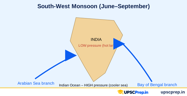
"Monsoon" comes from the Arabic mausim (season), meaning a seasonal reversal of winds. In summer, the land heats faster than the sea, so a low-pressure area forms over north-west India. Moist south-west winds then flow in from the Indian Ocean. In winter, the pattern reverses and dry north-east winds blow from land to sea.
Modern understanding adds:
- the shift of the ITCZ (inter-tropical convergence zone) north, to about 20–25°N over the Ganga plains in July;
- the sub-tropical westerly jet moving north of the Himalaya and the tropical easterly jet setting in over the Peninsula;
- the heating of the Tibetan plateau;
- ENSO – El Niño years often (not always) mean weak monsoons;
- the Indian Ocean Dipole (IOD) – a positive IOD often helps the monsoon;
- the Madden–Julian Oscillation (MJO), which affects active and break spells.
India's four seasons (IMD)
| Season | Months | Main features |
|---|---|---|
| Cold weather | Dec–Feb | Western disturbances bring rain to the north-west (good for wheat) and snow to the hills; Tamil Nadu gets NE monsoon rain (Oct–Dec) |
| Hot weather | Mar–May | Loo (hot winds) in the north; pre-monsoon showers: mango showers (Kerala, Karnataka), Kalbaisakhi/Nor'westers (Bengal, Assam), cherry blossoms (coffee areas) |
| SW monsoon | Jun–Sep | Arabian Sea branch (Western Ghats – heavy rain, rain-shadow on the Deccan) and Bay of Bengal branch (north-east India, Ganga plains); Mawsynram/Cherrapunji – among the wettest places on Earth |
| Retreating monsoon | Oct–Nov | "October heat"; cyclones in the Bay of Bengal; NE monsoon on the Coromandel coast |
Onset: normally over Kerala around 1 June, covering the whole country by about 8 July (IMD's revised normal dates since 2020).
Soils – the ICAR classification and what each grows
| Soil | Where | Character | Crops |
|---|---|---|---|
| Alluvial | Northern plains, deltas | Most widespread (about 40%); rich in potash, poor in nitrogen | Rice, wheat, sugarcane, pulses |
| Black (regur) | Deccan lava plateau – Maharashtra, Gujarat, MP | Clayey; holds moisture; cracks when dry; rich in lime, iron, magnesia | Cotton ("black cotton soil"), soybean, jowar |
| Red and yellow | Eastern and southern Deccan, Chota Nagpur | Red from iron oxide; yellow when hydrated | Millets, pulses, groundnut (with fertilisers) |
| Laterite | High-rainfall, high-temperature areas – the Western Ghats, Meghalaya | Leached; acidic; poor; used for bricks | Tea, coffee, cashew |
| Arid | Rajasthan | Sandy, saline; kankar layer | Bajra, with irrigation |
| Saline/alkaline | Dry areas, coastal Gujarat | Salt build-up from over-irrigation (reh, kallar) | Need gypsum treatment |
| Peaty/marshy | Kerala (Kuttanad), Sundarbans | Organic, high humus | Rice (special varieties) |
| Forest/mountain | Himalaya | Varies with altitude | Fruits, tea |
Natural vegetation – rainfall decides
| Type | Rainfall | Examples |
|---|---|---|
| Tropical evergreen | > 200 cm | Western Ghats, north-east, Andamans – ebony, mahogany, rosewood |
| Tropical deciduous (monsoon) | 70–200 cm | Most widespread: teak, sal, sandalwood |
| Thorn and scrub | < 70 cm | Rajasthan, the Deccan rain-shadow – acacia, khejri, cactus |
| Montane | Varies with altitude | Oak and chestnut → pine and deodar → alpine meadows (bugyals) |
| Mangroves | Tidal coasts | Sundarbans (sundari tree; Royal Bengal tiger), Bhitarkanika, Pichavaram |
India State of Forest Report (biennial, FSI): total forest and tree cover is about one-quarter of the geographical area. The National Forest Policy (1988) targets 33%.
Causes and effects – the monsoon economy
About half of India's net sown area is still rain-fed. A weak monsoon reduces kharif output, raises food inflation, cuts rural demand, lowers reservoir levels and hydropower, and increases farm distress. Climate change is making rain more erratic – fewer rainy days but more extreme rainfall events – which brings both floods and droughts.
Case study: Kerala floods of 2018
In August 2018, Kerala received far above-normal rainfall in a short span. With dams already full, several were opened together, and many districts were flooded. Studies pointed to extreme rain plus land-use change (quarrying and building on slopes and flood plains), as well as reservoir operation issues. The lesson: integrated reservoir management, flood-plain zoning and protection of the Western Ghats (debated in the Gadgil and Kasturirangan reports).
Common misconceptions
- "El Niño always causes drought in India." – Not always. A positive IOD can offset it (for example, 1997 saw a strong El Niño but near-normal rain).
- "Black soil is formed from alluvium." – It formed from the weathering of basalt (Deccan Traps lava).
- "Laterite soil is fertile because it is red." – It is poor, because heavy rain leaches nutrients.
How UPSC asks it
Prelims frequently asks about local winds, monsoon mechanisms (jets, ENSO, IOD), soil–crop matching, and vegetation types. Mains themes include monsoon variability and its impact, soil degradation, and climate change and Indian agriculture.
Mains answer framework
Q-type: "Explain the factors that affect the Indian monsoon. How is climate change making it more uncertain?"
- Introduction: definition and importance (about 70% of annual rain falls in June–September).
- Factors: differential heating, ITCZ, jets, Tibet, ENSO, IOD, MJO.
- Climate change: extreme events, delayed withdrawal, rising temperatures, Arabian Sea cyclones increasing.
- Measures: better forecasting (IMD's dynamical models), crop diversification, micro-irrigation, insurance (PMFBY), climate-resilient seeds.
- Conclusion: monsoon resilience as national security.
Mechanism of the Indian monsoon (exam summary)
- Differential heating of land and sea creates low pressure over north-west India in summer.
- The ITCZ shifts north, and the south-east trades cross the equator and become the south-west monsoon.
- The tropical easterly jet and the position of the subtropical westerly jet influence onset.
- El Niño is often associated with weaker monsoons, and a positive Indian Ocean Dipole can support rainfall.
Practice question
Q. Explain the distribution of black soils in India and their agricultural importance. Black (regur) soils formed from Deccan basalt cover much of Maharashtra and parts of Madhya Pradesh, Gujarat, Karnataka and Telangana; they hold moisture well and suit cotton, earning the name "black cotton soil".
Check your understanding
- Why does Tamil Nadu receive rain in winter? The north-east monsoon (retreating monsoon) picks up moisture over the Bay of Bengal.
- Which forests cover the largest area in India? Tropical deciduous (monsoon) forests.
- SW Monsoon June–Sept brings ~75% of the rainfall; Tamil Nadu gets its rain in Oct–Dec
- Black soil = cotton, moisture retention; laterite = leaching
- Tropical deciduous = most widespread forest